File:Cape Gracias a Dios.jpg
From Creolista!

Size of this preview: 375 × 600 pixels. Other resolutions: 150 × 240 pixels | 300 × 480 pixels | 480 × 768 pixels | 1,200 × 1,920 pixels.
Original file (1,200 × 1,920 pixels, file size: 1.46 MB, MIME type: image/jpeg)
Summary
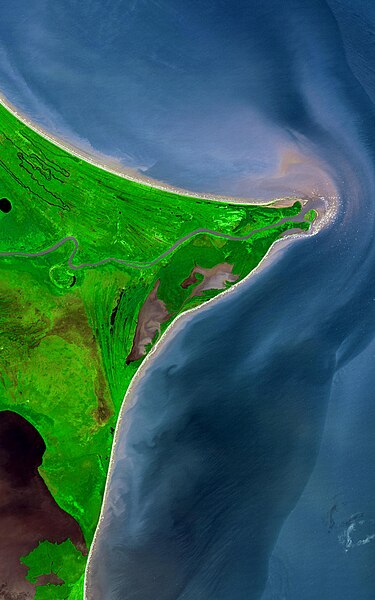
| Description | Around 15 degrees North, a rounded point of land juts out into the Caribbean Sea from the Central American isthmus. This low-lying, wet area is called the Mosquito Coast, a corruption of the tribal name of some of the area’s native people, the Miskito. The area includes parts of Honduras (north) and Nicaragua (south). Between the two countries flows the Coco River, which empties into the Caribbean at Cape Gracias á Dios. |
| Date | |
| Source |
http://earthobservatory.nasa.gov/Newsroom/NewImages/images.php3?img_id=17232
|
| Author | NASA/GSFC/METI/ERSDAC/JAROS, and U.S./Japan ASTER Science Team |
Licensing
| This file is in the public domain in the United States because it was solely created by NASA. NASA copyright policy states that "NASA material is not protected by copyright unless noted". (See Template:PD-USGov, NASA copyright policy page or JPL Image Use Policy.) | ||
 |
Warnings:
|
File history
Click on a date/time to view the file as it appeared at that time.
| Date/Time | Thumbnail | Dimensions | User | Comment | |
|---|---|---|---|---|---|
| current | 22:53, 12 August 2022 | | 1,200 × 1,920 (1.46 MB) | Thecaribbeancoast | Uploaded a more clearer and bigger photo |
File usage
There are no pages that link to this file.